MODEVRA
- MODELS FOR CRUSTAL DEFORMATIONS DETECTION FROM GPS AND SATELLITE
REMOTE SENSING DATA FOR SEISMIC RISK ASSESSMENT IN VRANCEA AREA
Objectives
-
to frame of Vrancea seismic area in the geotectonic context of alpine
catens from Central Europe
-
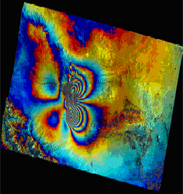
to determine crustal deformations which are relieved in Vrancea area
and their correlation with seismic events from
InSAR
satellite data, reference measurements in
GPS
observation stations localized as possible in geologic stable areas
-
modeling and quantifying surface crustal deformations regarding the
confirmation of the hypothesis about the existance of lithospheric
plate fragment subduction process where the most seismic events take
place
-
to compare GPS observation data and seismicity and geodezic baseline
studies over Vrancea active zone by the determination of geodezic
coordinates of the points in which
GPS measurements have
been done and geodynamic interpretation of the obtained results in
order to determine geodynamic models and to obtain their correlation
with seismic events
-
to precise localize deformation areas end to evidence the directions
and crustal blocks movement speed in order to determine or to confirm
high seismic risk areas
-
to elucidate geodynamic theories for the high seismic risk Vrancea zone
and in particular to clarify the state of the lithospheric plate
fragment and the possible sepration of it, also to investigate the
coupling/decoupling state of Carpathians by the determination of
crustal deformation parameters and those which define earth flows
for Vrancea zone