Theoretical background
Vrancea region, at the sharp bend of the Southeast Carpathians, is one of the
well-defined seismo-active areas of Europe. A narrow, near-vertical focal
volume subducted at intermediate depths (60 - 220 km), supposed to be in a
relic stage at present, is the site of an unusually intense seismicity
(an average frequency of 3 shocks with magnitude greater than 7 per century).
The main goal is to investigate the way the Vrancea subcrustal earthquakes
control the seismic hazard in Romania. The numerical synthesis of the
ground motion, taking into account the source, the seismic waves propagation
and the local site geology represents the key element for the ground motion
predictions.
The technology of
GPS geodesy
provides the best constraints on the rate of strain accumulation on active
and possible active faults.
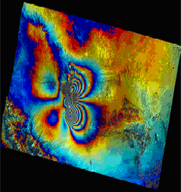
InSAR
from Earth-orbiting spacecraft provides a new tool to map global topography
and deformation of the Earth�s surface. Radar images taken from slightly
different viewing directions allow the construction of digital elevation models
of meter-scale accuracy. If the Earth�s surface deformed between two radar
image acquisitions, a map of the surface displacement with tens-of-meters
resolution and subcentimeter accuracy can be constructed.
Spatial technologies offer a source of complementary information for
ground-based sources. Multi-sensor remotely sensed data, such as aerial
photography,
ASTER, Landsat (
MSS,
TM Data,
ETM), IKONOS,
SPOT,
MODIS
imagery, are very useful for building the
DEM
and lineament analysis and consequently help more to the neotectonic mapping.
Infrastructure
Computing Working Stations, Satellite data
GER2600 Spectroradiometer
ENVI 4.1, IDL, ERDAS software
GPS network stations